

Northeast Vietnam Motorbike Adventures: Off-Road & On-Road Tours, 5-8 days loop.
Northeast Vietnam Motorbike Tours
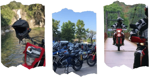
Northeast Vietnam motorbike tours take you into the least ridden corner of the north, covering around 1000 km from Hanoi through Bac Kan, Ba Be National Park, Cao Bang, and the border backroads near China before returning south via Lang Son or Thac Ba lake. Expect jungle river trails, karst valley tracks, narrow Chinese border roads, waterfalls and the Nang River crossing where the bikes go on boats into Ba Be National Park. I am Hamid, lead rider at IRTouring, and I have been guiding riders on these routes since 2013 on itineraries that i call, unique.


Explore northeast Vietnam motorbike tours
Our northeast Vietnam motorbike tours run from 7 to 9 days, all starting from Hanoi and heading into the border provinces of Cao Bang, Bac Kan, and Lang Son. The Border Ride is our most popular option, covering Cao Bang, Ban Gioc waterfall, the Nang River crossing, and Ba Be Lake. The 9-Day Northeast Extension adds the Ban Gioc waterfall and quietest border sections near That Khe and Quang Uyen for riders who want more time and more distance from the main roads.
- Check out Full motorbike tours around northern Vietnam
- See Northwest Vietnam motorbike adventures
- Ha Giang loop motorbike adventures
Off-road motorbike tours in northeast Vietnam
Our northeast Vietnam off-road motorbike tours are not the most technically extreme routes in the north, but they are among the most remote. The terrain covers narrow border tracks near That Khe and Quang Uyen, riverside backroads that shifts to wet trails.
The 9 day Northeast Off-Road Extension pushes deep into the border backroads parallel to China, passing through Nung villages, Cao Bang and the God’s eye mountain. The Northeast Border Dirt Ride combines with unpaved tracks north of Bac Kan, finishing with the Nang River boat crossing into Ba Be.
On-road northeast Vietnam motorbike tours
For riders who want to cover the northeast on paved roads but still ride the dramatic mountain passes, then my on-road northeast motorbike adventures follow hidden backroads through open karst valley, quiet border towns.
Ba Be Lake & Cao Bang on northeast Vietnam motorbike tours
Ba Be Lake and Cao Bang are the two destinations of every northeast Vietnam motorcycle trip and they are completely different from each other. Cao Bang sits 272 km from Hanoi in open karst country where the peaks rise sharply out of flat rice paddies.
Ba Be Lake is 8 km long, sits at 145 meters elevation inside Ba Be National Park, and on my tours the group arrives by boat from the Nang River through Puong Cave, a 300-meter limestone cave with a river running through its floor. You’ll be lodging at home-stay on the southern side of Ba Be Lake, where I arrange accommodation directly with local Ethnic minority families.

Bikes and riding gear
The northeast trails works on a range of bikes because the terrain is varied but not extreme at the standard level. The Honda XR150 and XR190 handles the rides perfectly.
For the longer rides with more dirt sections around That Khe and Quang Uyen, the CRF250 and CRF300 are the better choice. They give you more control on the terrain after rain. The CB500X works well on the road-trips and backroad sections and covers daily distance efficiently, but it is heavier. A support mechanic rides sweeper on all northeast Vietnam motorbike trips.

Why ride northeast Vietnam?
The northeast is the less crowded riding options in northern Vietnam. It does not have the high pass counts of the northwest or comparing to the Ha Giang, but it offers something both of those regions do not: genuine remoteness at low elevation.
The border backroads near That Khe and Quang Uyen see almost no riders. The karst landscape around Cao Bang is open and panoramic in a way that feels different from the tighter mountain passes further west. I have been running northeast tours since 2013 and this region still gets less attention than it deserves.
Best time to ride the northeast loop
September and October are the two months I recommend most for northeast Vietnam motorbike tours. Ban Gioc waterfall runs stronger after the summer rains, the rice fields around Cao Bang and Trung Khanh are active before harvest, and the border backroads are firm enough for consistent daily riding. Daytime temperatures in Cao Bang sit between 18 and 26 degrees Celsius in this time of the year.
October through April is dry season. Tracks firm up and stay dry and sunny. January and February bring cold fog into the Cao Bang valleys overnight but it clears by mid-morning on most days. Pack a warm layer for early starts between December and February.
May to August is wet season. The Nang River flow higher. The border trails near That Khe become unpredictable after heavy rain.
Off-road vs on-road – which tour is right for you?
Off-road tours cover narrow border tracks, riverside dirts, and loose clay sections that turns into massive wet trails after rain. These routes require comfort on unpredictable ground and confidence managing a bike on trails.
On-road tours follow sealed backroads through karst valley and quiet border towns with minimal traffic. These suit intermediate riders who want the remoteness of the northeast without the demands of technical dirt riding.
Cultural stops along the northeast loop
The northeast has four ethnic groups living along the route in villages. Tay communities farm the Ba Be Lake and the river valleys north of Bac Kan. Nung villages run along the Chinese border near That Khe and Quang Uyen. Dao settlements sit in the hills above Cao Bang. Hmong communities appear on the higher ground between Lang Son and the return south.
The difference between riding through these villages and actually stopping comes down to the guide. No part of this loop is set up as a cultural tourism center. The villages are working communities and the interactions that happen on this route are the kind that do not get arranged in advance.
support options
All northeast Vietnam motorbike tours can be supported by a track, carrying gear, spare parts, and any rider who needs a break from the bike. This works well for groups with mixed experience levels. I always recommend the support vehicle on the longer northeast itineraries given the fuel gaps and the distance from any town with a mechanic.
Plan Your Northeast Vietnam Adventure
Ba be, Cao Bang, Ban Gioc and border routes are only a few of what northeast Vietnam is all about. Book a motorbike tour and ride across the terrain, the remoteness, and the access that the main tourist loops do not. I customize every northeast itinerary around your exact riding demand, experience, and time of year.
Get in touch and I will put together the right route for your level and schedule.
