

Join an adventure ride up-close along the front-line, Off-road, local cultures & more.
Best Ha Giang Motorbike Tours
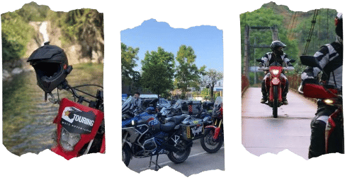
Ha Giang is the most dramatic region in northern Vietnam, sitting high along the Chinese border where the landscape shifts between limestone peaks, deep canyon roads, and remote hill tribe villages. The private Ha Giang Loop motorbike tours I offer start and end in Hanoi, covering the full circuit through the Dong Van Karst Plateau, Ma Pi Leng pass, Lung Cu, and back, with H’mong, Tay, and Dao villages throughout. Routes are available on-road or off-road, across 7 to 14 days, and tailored to your riding level and schedule. This is the most rewarding ride in northern Vietnam for riders who want real terrain and real places.


The Ha Giang loop is the most varied and demanding motorbike tour in northern Vietnam. The route runs from Hanoi deep into Ha Giang province, crossing the Dong Van Karst Plateau, the Ma Pi Leng pass, and the stone highlands near the Chinese border before looping back south through Ba Be or Thac Ba. All tours are private, fully guided, and built around your riding experience and expectations. Off-road single tracks or long mountain road days on a touring bike, I can tailor the route and pace to fit you and your group.
- Check out Northeast motorbike tours
- Get more ideas on Northwest motorbike tours
Private Ha Giang Loop Motorbike Tours
All Ha Giang loop tours I run are private departures starting from Hanoi. No fixed group schedules. Routes and durations are matched to your riding level, pace, and the time you have available.
7 days covers the core loop: Ha Giang city, Quan Ba, Yen Minh, Dong Van, Lung Cu, Meo Vac, and Ma Pi Leng pass before heading back. Enough time to ride each section properly without rushing any of it.
8 to 9 days adds time for side tracks into Sung La Valley, extra days in Hoang Su Phi, or short off-road sections between the main passes. Better suited for riders who want more time in the saddle on smaller terrain.
12 to 14 days is the full northern circuit. The route extends east toward Cao Bang, That Khe, and Ban Gioc, or west through Sapa and Bac Ha. Remote roads, minimal traffic, and a completely different landscape each day. Around 1,400 to 1,600 km in total depending on the variation.
Off-Road Motorbike Tours in Ha Giang
The off-road tours around Ha Giang are planned around terrain. Routes include single tracks through Sung La Valley, dirt trails across the Dong Van plateau, forest roads between Ma Pi Leng and Bao Lac, and bamboo raft river crossings in the lowland sections. These are not detours added onto a road route. The off-road tracks are the route.
These tours are suited to intermediate and advanced riders. You should be comfortable on loose gravel, steep hills, and uneven tracks before joining the motorbike adventure. If you are unsure of your riding level, i can customize a tour that fits your riding expectations, Ha Giang has it all.

On-Road Motorbike Tours of Ha Giang
For riders who prefer tarmac, the on-road tours around Ha Giang follows paved backroads and mountain passes across the region. The route covers Ma Pi Leng, Lung Cu, Quan Ba Heaven Gate, and the Hoang Su Phi terraces, not the road 197. No dirt sections and no technical terrain. The on-road tours are well suited to intermediate riders and anyone who wants to focus on distance and scenery over trail conditions.
Recommended Bikes for the Ha Giang Loop
Bike recommendations are depends on the route type and your riding background. All bikes are fully maintained before and throughout the trip. A support mechanic follows behind on every group tour, to ensure the tour runs with no issue.
| Category | Bike Options | Best For |
|---|---|---|
| Light off-road | Honda XR150, Honda XR190 | Beginner to intermediate riders, mixed terrain, easy handling |
| Full off-road | Honda CRF 250, Honda CRF 300 | Advanced riders, technical trails, rough terrain |
| On-road touring | Honda CB500X, BMW GS, Triumph Tiger GT Explorer | Long distance comfort, paved mountain roads |
| Classic touring | Triumph Scrambler 900 | Style-focused riders, road riding with character |
Key Destinations on the Ha Giang Loop
Ma Pi Leng Pass
Ma Pi Leng connects Dong Van and Meo Vac across 20 km of cliff-edge road above the Nho Que River canyon. Tight switchbacks, steep exposure, and one of the most technically engaging sections on the entire loop.
Dong Van Karst Plateau Geopark
A UNESCO Global Geopark covering 2,300 square kilometres of limestone formations, deep valleys, and highland villages. H’mong and Lo Lo communities spread across the plateau at elevations above 1,500 metres.
Lung Cu Flag Tower
The northernmost point of Vietnam, around 20 km from Dong Van. Traditional H’mong villages and terraced farmland surround the site. A short walk from the parking area takes you to the top of the tower.
Sung La Valley
A quiet valley running between limestone peaks south of Dong Van. Dirt tracks, H’mong villages, and terraced fields that shift colour through the seasons. One of the best off-road sections on the full circuit.
Quan Ba Heaven Gate
The first major pass heading north from Ha Giang city. Wide open valley views and a clear sightline to the Twin Mountains rising from the valley floor below.
Hoang Su Phi Terraced Fields
Located south of Ha Giang city. Most striking during the September to October harvest season when the terraces turn gold across the hillsides.
Ban Gioc Waterfall and Cao Bang
Reached on the extended northeast route before entering Ha Giang province. Ban Gioc sits on the Chinese border and is one of the largest waterfalls in Southeast Asia. The road from Cao Bang to Ha Giang is remote and sees almost no tourist traffic.
What Is Included in Your Ha Giang Tour
Every tour includes the following as standard:
- Private guiding by an experienced local guide throughout
- Bike hire with full mechanical support and a trailing mechanic each day
- Accommodation (guesthouses and homestays along the route)
- Breakfast and dinner daily
- Fuel costs for your bike
- Route planning and daily briefings matched to conditions
Not included: international flights, travel insurance, personal spending, lunches, and alcoholic drinks. Travel insurance covering motorbike riding is required on all tours.
Ha Giang Loop Tour Pricing
Pricing depends on trip duration, group size, bike type, and not route variation. All tours are private, but i dont charge for single surcharge on hotels. Contact me with your dates, preferred bike, and group size and I will send a full quote within 24 hours.
Solo riders, couples, and small groups of up to 6 are all welcome. Larger groups can be accommodated with advance notice.
Safety and Riding Level Required
Ha Giang is not a beginner route. The roads are narrow single track, the elevation is high, and sections of the off-road loop require real bike control. That said, the on-road loop is accessible to intermediate riders who are comfortable with mountain roads and long daily distances.
I assess every rider’s experience before finalising a route. If your level does not match the planned terrain, I will tell you directly and suggest a better-fit alternative. Safety is not adjusted based on what riders want to hear.
All tours run with a trailing support vehicle and mechanic. Emergency contacts and route contingencies are planned before each day starts.
Off-Road vs On-Road: Which Loop Is Right for You?
Off-road tours are built for experienced riders comfortable with dirt trails, technical descents, river crossings, and remote terrain far from sealed roads.
On-road tours follow the full Ha Giang loop on tarmac and mountain passes. Long days, strong elevation gain, and consistently engaging riding conditions without technical terrain.
Not sure which suits your level? Contact me and I will match the route and bike to where you are as a rider.
Frequently Asked Questions: Ha Giang Motorbike Tours
How long does the Ha Giang loop take?
A 7-day tour covers the core circuit at a reasonable pace. 8 to 9 days gives more time for side routes and off-road tracks. The full northern circuit, including Cao Bang or Sapa, runs 12 to 14 days.
Do I need a Vietnamese motorbike licence?
Foreign riders are technically required to carry an International Driving Permit (IDP) endorsed for motorcycles. I recommend getting one before you travel. On private guided tours, the guide handles all local logistics, but carrying your documentation is always advisable.
What is the best time to ride Ha Giang?
October and November bring clear skies, cool temperatures, and the buckwheat flower season across the plateau. March and April also offer good riding weather with spring blossoms. July and August bring the highest rainfall and the most difficult road conditions, particularly on dirt sections.
Is the Ha Giang loop safe?
90% of my client are experienced riders, so yes, it’s 100% safe. Tours run with a trailing mechanic, daily route briefings, and contingency plans for each section. Rider experience level is assessed before any tour departs. I do not take riders onto terrain that does not match their skill.
Can beginners ride the Ha Giang loop?
Yes sure! The on-road circuit is suitable for intermediate riders who are confident on mountain roads. True beginners are not recommended for this route without prior experience on similar terrain. Contact me and I can advise on alternative northern Vietnam routes that suit your current level.
What should I pack for the Ha Giang loop?
Riding gear including a full-face helmet, gloves, jacket, and over-trousers. Layers for cold mornings above 1,500 metres, a rain layer, and a small day pack. I provide a full kit list after booking.
Plan your Ha Giang loop motorbike tour
I’m Hamid from IRTouring. I run private motorcycle tours across Vietnam and Laos for riders who want real routes, real terrain, and none of the group tour compromise. Honda XR150, CRF250, CB500X, and BMW GS bikes maintained and ready. Routes built around where you actually want to go.
Ready to ride Ha Giang? Get in touch and let’s plan it.
